Environment | Oceanography
Coastal Crete: Oil Spill Response
Coastal Crete is the Cretan Sea Digital Twin of Iliad, co-developed by partners FORTH and MEEO, that provides to users advanced, high-resolution forecasting services, enhanced by the integration of Sentinel data, real-time in-situ observations and Machnine Learning algorithms, allowing the simulation of (what-if) predictive scenarios.
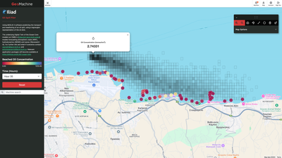
The Oil Spill Response Ocean Twin provides early detection of marine oil spills, and accurate, short-term operational forecasting of spill trajectories to support immediate response to pollution events, minimizing thus the impact on marine ecosystems, coastal communities and the economy and reducing the time for environmental recovery. A multi-model approach is followed for predicting the fate and transport of oil spills, employing particle tracking models, coupled to operational, high-resolution numerical weather (WRF), hydrodynamic (NEMO) and sea state (WAVEWATCH III) models for Cretan Sea. A near-real time automatic oil spill detection system, from Sentinel-1 SAR images is developed, which allows early detection of marine oil spills and triggers the oil spill forecasting system, producing accurate short-term forecasting of spills’ trajectories and fate.
An Jyputer notebook link has been created to guide users for data discoverability and download.
The Oil Spill Response Digital Twin also provides: (i) the operational picture for the deployment of technical response measures combining high-resolution met-ocean operational forecasting data, and in-situ observations and (ii) oil spill forecasting as an on-demand service/tool to users for simulating (what-if) predictive scenarios of oil spills, using also different meteorological and hydrodynamic forcing and ensemble forecasts to assess models’ uncertainty. The on-demand tool is applicable for the global ocean.
The model has been dockerized and distributed in the INESCTEC application package registry and can be run with a single command line like so:
cwltool https://raw.githubusercontent.com/ILIAD-ocean-twin/application_package/refs/heads/main/cretan_oilspill/medslik.cwl#medslik input.json
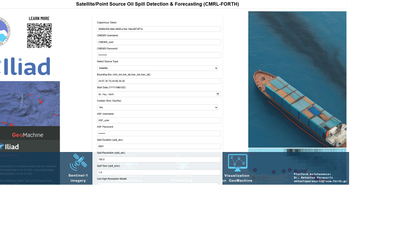
An additional tool for a more complex pipeline that has options for running either from satellite to forecast, or point source oil spill forecasts can be found on
GITHUB: Cretan oil spills page and a tool is available on the application package registry that can cut the global ocean bathymetry at the area of interest for the oil spill simulation, and thus reduce container sizes and improve computational time.
The visual engine has been created through Geomachine platform where a machine has been set up named Oil Spills that takes the output of the dockers (spill_properties.nc file) and automatically creates an interactive visualisation on the map. There is also the option to run with EDITO, and Geomachine frontend connects to EDITO Datalab and initiates a process on playground that runs the MEDSLIK pipeline with the options given at the Geomachine Frontend. After the simulation ends, the results are fetched and visualized to Geomachine Oil spill frontend.
Associated Products
Additional Details
Type: Web Applications, Data Sets, Container Images
Theme: Environment, Oceanography, Physics, Research, Iliad: Pilots
Iliad Project Component
Dataset sources: CMEMS
Language(s): English
Contact Information:
Vassiliki Metheniti
Researcher
CMRL, FORTH
Screenshots


Parameters
Hover over parameters to read the definition.
Laboratory Feedback
Laboratory products are in active development and we welcome your feedback to help product owners create the best products possible.