Environment | Meteorology
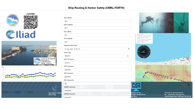
Coastal Crete: Ship routing/Harbor Safety
Coastal Crete is the Cretan Sea Digital Twin of Iliad, co-developed by partners FORTH and MEEO, that provides to users advanced, high-resolution forecasting services, enhanced by the integration of real-time in-situ observations, allowing the simulation of (what-if) predictive scenarios. Application packaging was assisted by Iliad partner Hidromod. Visualization was enabled by Iliad partner Blue Lobster through Geomachine.
A Jyputer notebook link has been created to guide users for data discoverability and download through ADAM API.
The Ship routing/Harbor Safety Ocean Twin offers two key application packages aimed at optimizing maritime operations and enhancing harbor safety.
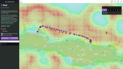
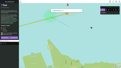
The first application provides a solution for calculating optimal ship routes, designed to minimize cumulative distance, travel time, and CO2 emissions. This tool uses VISIR-2 software (created by CMCC, Italy) and leverages advanced algorithms to determine the most efficient paths for vessels, offering real-time and predictive insights. The results are seamlessly visualized through the GeoMachine platform, enabling users to interact with and adjust routes based on dynamic marine conditions.
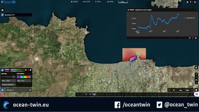
The second application focuses on high-resolution wave forecasting, using a 50-meter spatial resolution model to deliver accurate 3-day wave forecasts. This model, based on the SWAN model, predicts wave heights and directions critical for safe harbor operations. The forecasts are visualized through the ADAM platform, providing users with a powerful tool for monitoring and decision-making, ensuring safety and efficiency in harbor management and coastal navigation. Both applications are designed to meet the operational needs of global maritime industries, and integrate Hydromast sensor data from the port of Heraklion in order to be triggered when severelly adverse weather conditions affect the area. Swan model docker is available through Iliad's dedicated Github repository SWAN, Github repository Ship routing and the application packages are available through INESCTEC unified catalogue of application packages. CWL for ship routing , as well as CWL for SWAN 50m in Heraklion Port.
Additionally this DTO supports data from Hydromast sensors that support Harbor safety via alerts for extreme conditions. These data are uploaded in EMODNET and are freely available after login into the platform.
Title: Multi-Depth Velocity, Direction, Pressure, and Temperature Measurements in Heraklion Port
URL: https://emodnet.ec.europa.eu/ingestion/ds/submissions/d10f8103-4e2e-4c72-8724-f01fa70999da
link to download 3 month data (from reinstallation):
https://cloud.emodnet-ingestion.eu/index.php/s/I0Fwq4kFmLd7LrJ
A visual front end with the option to download raw data from Heraklion port is also available and maintained by Talteck, and can be found here
Associated Products
Additional Details
Type: Container Images, Web Applications, Data Sets
Theme: Environment, Meteorology, Oceanography, Research, Iliad: Pilots
Iliad Project Component
Dataset sources: CMEMS, Emodnet
Language(s): English
Contact Information:
Antonios Parasyris
Postdoctoral Researcher
CMRL FORTH
antonisparasyris@iacm.forth.gr
Screenshots
Laboratory Feedback
Laboratory products are in active development and we welcome your feedback to help product owners create the best products possible.