Blue Economy | Research
VISTools
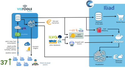
VISTools is the North Sea Fisheries Pilot of Iliad, designed to support the Belgian fleet with advanced decision-making tools. By leveraging real-time data collection and predictive models, VISTools enhances operational efficiency. The pilot includes three key tools: Analytics, Fishing Suitability, and Vessel Routing—the latter currently under development.
To ensure the replicability of this Digital Twin of the Ocean (DTO), a comprehensive documentation has been created. It provides a step-by-step guide to building VISTools, covering key aspects such as end-user engagement, sensor integration, model training, data visualization, and the technical components needed for full deployment. You can access the documentation in this link. You can also reach out to Lancelot Blondeel (lancelot.blondeel@ilvo.vlaanderen.be) or Clyde Blanco (clyde.blanco@ilvo.vlaanderen.be) to request for a demo.
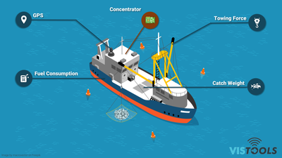
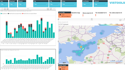
VISTools Analytics provides vessel owners with real-time insights into fishing operations while their vessels are at sea. This interactive tool delivers essential business intelligence, including catch composition by species and fuel consumption during both steaming and fishing. Data can be viewed at multiple levels—aggregated for an entire trip or broken down by specific hauls and days. To achieve this, sensors are installed on vessels to capture key operational data. These include (a) scale that weighs catches per species, (b) engine sensor that records fuel consumption, (c) sensor attached to the net which measures rope length and traction force, and (d) GPS tracking that logs vessel location and movements. A dedicated onboard device, called concetrator, integrates all sensor data and transmits it to the cloud for processing and analysis. The results are then displayed on an interactive Power BI dashboard, providing vessel owners with real-time operational insights. You can discover the dummy data through here ⬇️.
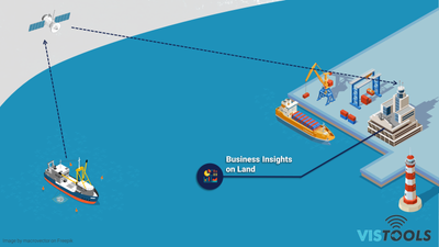
Beyond fishing operations, vessels equipped with VISTools Analytics serve as automated data collection platforms for meteorological and oceanographic parameters. Additional sensors attached to the net measure depth, temperature, salinity, and turbidity when submerged. Once the net is retrieved, these data points are automatically transmitted to the onboard concentrator for further processing. ILVO is not the owner of this data but the vessel owners, hence data access can only be granted with their approval through a data sharing agreement.
VISie Fishing Opportunity Explorer forecasts the most suitable areas to catch common sole (Solea solea) and European plaice (Pleuronectes platessa) up to seven days in advance. The tool is powered by a Machine Learning (ML) model that integrates various environmental predictors and their historical trends with catch observations. These observations come from fisheries-dependent sampling and data collected through VISTools Analytics. The fused dataset is used to train, tune, calibrate, and validate multiple ML algorithms, ensuring accurate and reliable predictions for optimal fishing locations. To learn more on how we developed this tool, refer to this link.
VISTools Vessel Routing will help skippers navigate to fishing areas via optimized routes that minimize fuel consumption. The VISIR II ship routing model has been added into an application package developed by the Foundation for Research and Technology – Hellas (FORTH). The simulated routes incorporate real-time water and weather conditions to enhance fuel usage efficiency. Currently, this can't be incorporated yet into VISTools because the suggested vessel speeds are too fast for a fishing vessel. Further development needs to be done to calibrate the model with fuel consumption and speed values from fishing vessels. We have described here how we tested the aplication package.
📢Important to Know
VISTools can only be accessed through the official website. However, due to the sensitive nature of the catch data collected from fishing vessels, access is restricted to VISTools registered users only (i.e., vessel owners). Users with ILIAD credentials don't have access to this tool. However, we have created a demo PowerBI dashboard for the VISTools analytics showing dummy data. You can download the PowerBI file here ⬇️ or through the Files tab.
Similarly, the latest forecasts from the VISie Fishing Opportunity Explorer are currently available exclusively to registered VISTools users actively providing catch data for model training and improvement. This restriction is in place because the model relies on sensitive catch data derived from their historical fishing activities and the model can potentially reveal these "trade secrets". To see how the dashbord works, you can access a demo dashboard visualising past forecasts. The dashboard is by default in Dutch but you can switch it to English using the language selection tool found on the upper right corner of the dashboard. We have developed a demo image which contains the same ML workflow (i.e., the same CMEMS and EMODnet predictors) but using catch data from ICES surveys.
Associated Products
Additional Details
Type: Container Images, Data Sets, Script, Web Applications, Desktop Application
Theme: Blue Economy, Research, Fisheries, Iliad: Pilots
Iliad Project Component
Dataset sources: Marine Copernicus, EMODnet, Fisheries-Dependent Sampling, Vessel Sensors
Language(s): English, Dutch
Contact Information:
Lancelot Blondeel
Research Associate
Instituut voor Landbouw-, Visserij- en Voedingsonderzoek (ILVO)
lancelot.blondeel@ilvo.vlaanderen.be
Screenshots
-400x225.png)
-1-400x225.png)
Parameters
Hover over parameters to read the definition.
Feedback
Have you used this product? Please provide feedback to help product owners improve the quality of their products.