Environment | Oceanography
A Digital Twin for Oil Spill Incidents in the North Aegean
The North Aegean Sea, a critical maritime region in the eastern Mediterranean, is a vital artery for shipping, with oil tankers frequently navigating its waters to transport crude from Black Sea ports through the Dardanelles to western refineries.
This bustling traffic, combined with the region's proximity to major oil routes and its complex network of islands—such as Lesbos, Chios, and Samothrace—elevates the risk of oil spills. These incidents threaten the area's rich biodiversity, home to species like monk seals and loggerhead turtles, as well as its coastal economies reliant on fishing and tourism, with hubs like Alexandroupolis and Kavala at stake. Traditional oil spill detection methods have often faltered in this area, challenged by the region's strong currents, seasonal winds, and the difficulty of distinguishing spills from natural phenomena like upwelling or algae blooms.
Our solution introduces a pioneering approach to oil spill monitoring, designed specifically for the North Aegean's unique environmental and maritime conditions. By treating oil spills as anomalies against typical sea surface patterns, we utilize satellite imagery from platforms like Sentinel-1, paired with sophisticated machine learning algorithms, to detect and track spills with precision. This system analyzes baseline oceanic data, such as temperature, salinity, and current flows, sourced from regional monitoring networks and global datasets, enabling rapid identification of spill events. The application we've developed empowers stakeholders, from local authorities in ports like Alexandroupolis and Kavala to international environmental groups, to monitor spill risks in near real-time, visualize spill trajectories across the North Aegean's island-dotted expanse, and take preemptive action to protect its fragile ecosystems and vibrant coastal communities.
The North Aegean: Oil Spill Incidents Digital Twin, part of the ILIAD framework, is a cutting-edge digital tool crafted by the Laboratory of Ecological Engineering & Technology at Democritus University of Thrace. The North Aegean Oil Spill DT consists of:
Designed for rapid response, the Oil Spill Digital Twin detects marine oil spills early and provides reliable, short-term predictions of oil spill paths. It delivers high-precision forecasting capabilities to users, leveraging Sentinel-1 satellite data, live in-situ measurements, and advanced Machine Learning techniques to model predictive (what-if) scenarios with exceptional detail. This enables swift action to curb pollution incidents, safeguarding marine habitats, coastal populations, and economic interests while accelerating environmental recovery. The system employs a sophisticated multi-model strategy, integrating particle tracking with high-resolution hydrodynamic and wave data from the Copernicus Marine Environment Monitoring Service (CMEMS) and weather forecasts from the European Centre for Medium-Range Weather Forecasts (ECMWF), all fine-tuned for the North Aegean Sea. It features an automated, near-real-time oil spill detection mechanism using Sentinel-1 SAR imagery, which activates the forecasting system to deliver precise projections of spill movement and outcomes.
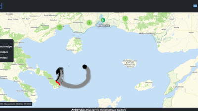
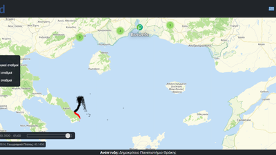
The North Aegean: Oil Spill Incidents Digital Twin currently offers users a detailed visualization of past oil spill detections, integrating CMEMS and ECMWF met-ocean data with on-site observations to map historical events accurately. Looking ahead, future enhancements will empower users with an on-demand simulation tool, enabling them to craft their own (what-if) oil spill scenarios. This tool will enable users to run simulations by adjusting variables such as oil type from the ADIOS Oil Database, spill mass, or the exact area or point of detection, tailoring predictions to specific conditions.
Visualization is driven by the Oceancast platform, featuring a specialized "Oil Spills" module that processes model outputs (oil-spill properties) to generate dynamic, interactive maps for the North Aegean region. Currently, users can explore detected oil spills, tracking their paths and affected areas, with currents, weather, and wave conditions from the incident period visualized as moving particles.
Additionally, a user-friendly tool for detecting oil spills has been created as a Jupyter Notebook, offering an accessible and straightforward way for users to test and explore the system’s oil spill detection capabilities.
ℹ️Important to Know
Access to the Jupyter Notebook requires ILIAD credentials. To run the tool, users must also switch to the ai4eo-snap server by selecting File → Hub Control Panel → Stop Server → Start My Server → ai4eo-snap.
Associated Products
Additional Details
Type: Data Sets, Script, Web Applications, Desktop Application
Theme: Environment, Oceanography, Physics, Research, Maps, Iliad: Pilots
Iliad Project Component
Language(s): English
Contact Information:
Nikolaos Kokkos
Researcher
Democritus University of Thrace
Screenshots

Laboratory Feedback
Laboratory products are in active development and we welcome your feedback to help product owners create the best products possible.