Blue Economy | Research
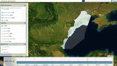
Black Sea Fisheries - Habitat Suitability Index for Golden Grey Mullet (Chelon auratus) and Turbot (Scophthalmus maximus)
The Black Sea Fisheries Digital Twin is implemented in the northwestern part of the Black Sea. Covering the shores of Romania, Bulgaria and Ukraine, this use case aims to provide a modern, intuitive tool for the fishermen.
Habitat Suitability Indices (HSI) are used to reflect the optimal conditions for specific species and represents the main output of Sepcies Distribution Modelling (SDM). In this particular case, the HSI was calculated for two species, both highly important from economic point of view: the Golden Grey Mullet (Chelon auratus) and the Turbot (Scophthalmus maximus).
For the his computation, several predictive parameters were used, most of them delivered by the Copernicus Marine Service (CMEMS):
For the Golden Grey Mullet, besides bathymetry, all other the results are on a daily basis and cover the period between 01.01.2018 – 31.12.2021.
While for the mullet the modelling was performed on existing information regarding the environmental envelopes (sustained by experts opinion), for the turbot analysis a dedicated model was constructed using the in-situ catch data provided by the National Institute for Marine Research and Development. This regionally calibrated model was then applied to monthly datasets, for a ten years period (January 2013 - December 2022).
The technical concept of the pilot, built also with GeoServer, is designed for interoperability.
The HSI datasets are exposed through standardized Open Geospatial Consortium (OGC) web services.
Web Map Tile Service (WMS / WMTS)
The links for raw data download:
Additional Details
Type: Data Sets, Standards, Web Applications, Script
Theme: Blue Economy, Research, Environment, Maps, Iliad: Citizen Science
Iliad Project Component
Dataset sources: Sea Surface Temperature, Salinity, Primary Production, Sea Surface Height, Currents Velocity, and Dissolved Oxygen (sourced from Copernicus Marine Service - CMEMS), alongside marine fronts derived from temperature products and bathymetry from GEBCO.
Language(s): English
Contact Information:
Marius Budileanu
TERRASIGNA
marius.budileanu@terrasigna.com
Screenshots
Feedback
Have you used this product? Please provide feedback to help product owners improve the quality of their products.