Oceanography | Environment
Biodiversity & Seascape
Our Twin Lab project aims to revolutionize the assessment of coastal biodiversity and seascape dynamics using advanced data analysis techniques. Leveraging cutting-edge technologies, our initiative seeks to unveil the intricate relationships between marine habitats and their inhabitants, ultimately contributing to more effective conservation and management strategies.
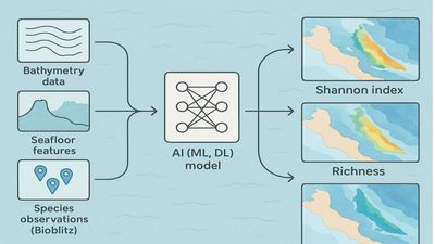
With a focus on understanding the complex interactions within coastal ecosystems, our project integrates multidisciplinary data sources, including bathymetric surveys, habitat mapping, and biodiversity assessments. By employing innovative analytical approaches, we aim to extract meaningful insights into habitat suitability, species distribution patterns, and ecosystem health.
Key Features:
Comprehensive Data Integration: Our project aggregates diverse datasets, including bathymetric maps, species observations, and environmental variables, to provide a holistic view of coastal ecosystems.
Advanced Analytics: We utilize state-of-the-art analytical techniques, such as machine learning algorithms and spatial modeling, to analyze complex spatial and temporal patterns in biodiversity and seascape dynamics.
Decision Support Tools: Our project develops decision support tools and habitat suitability models to aid in ecosystem management and conservation planning, empowering stakeholders with actionable insights.
Collaborative Framework: We foster collaboration among researchers, conservationists, and policymakers to facilitate knowledge exchange and promote evidence-based decision-making for coastal management.
Through our Twin Lab project, we strive to advance scientific understanding of coastal biodiversity and seascape dynamics, paving the way for more informed conservation efforts and sustainable marine resource management.
Additional Details
Type: Web Applications, Mobile Applications, Desktop Application, Data Sets, Standards, Script, Documentation
Theme: Oceanography, Environment, Maps, Research, Iliad: Pilots
Iliad Project Component
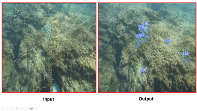
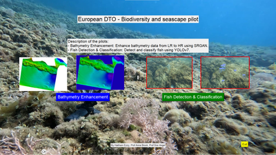
Dataset sources: Our product utilizes data collected from a diverse range of sources, including Lidar, Multibeam Echo Sounding (MBES), and underwater photogrammetry. Additionally, we incorporate data obtained from fixed underwater cameras for video recordings. This comprehensive dataset forms the foundation for building a robust model for fish detection and classification, ensuring accurate and reliable results.
Language(s): English
Contact Information:
Haitham Ezzy
Pilot Leader
University of Haifa
Screenshots
Laboratory Feedback
Laboratory products are in active development and we welcome your feedback to help product owners create the best products possible.