The European Union (EU) has established comprehensive policies to safeguard water quality and combat marine pollution, aiming to ensure access to clean water for all Europeans and to protect aquatic ecosystems. The overarching objective is to achieve good status for all water bodies across Europe.
The Water Framework Directive (WFD) commits Member States to achieving good qualitative and quantitative status of all water bodies. It serves as a foundation for water protection and management within the EU. The directive emphasizes the necessity of reducing chemical and nutrient pollution, particularly from agriculture and industry, which contributes to water quality degradation and eutrophication.
The Marine Strategy Framework Directive (MSFD) (Directive 2008/56/EC) is a pivotal policy that seeks to achieve Good Environmental Status (GES) of the EU's marine waters and to protect the resource base upon which marine-related economic and social activities depend. It addresses various descriptors, including biodiversity, fish populations, eutrophication, and contaminants. The directive promotes integrated monitoring strategies and encourages the adoption of innovative technologies for marine pollution assessment.
In 2019, the European Parliament voted to ban single-use plastics to tackle plastic pollution at its root, reflecting the EU's commitment to reducing marine litter. However, challenges persist in harmonizing national implementation strategies, and addressing knowledge gaps in plastic waste distribution remains critical.
Additionally, UN SDG6 has set ambitious targets to improve water quality by 2030[https://sdgs.un.org/goals/goal6#targets_and_indicators].
Nonetheless, despite the robust policy framework, there remain several challenges that can impede the attainment of water quality and pollution control objectives.
- Oil Spills: The absence of harmonized frameworks and coordination across jurisdictions, especially during cross-border incidents, leads to delayed responses. Limited real-time hazard mapping and forecasting capabilities exacerbate the situation.
- Plastic Pollution: The lack of harmonization among EU countries complicates the implementation of directives like the MSFD. Data gaps regarding the distribution and sources of marine plastic waste hinder effective policy formulation and enforcement.
- Water Quality Degradation: Nutrient runoff results in eutrophication, causing biodiversity loss. There is a scarcity of tools for continuous and scalable water quality monitoring, making it challenging to assess and manage water quality effectively.
- Chemical and Industrial Pollution: Industrial discharges and agricultural runoff introduce hazardous substances into marine environments, posing risks to biodiversity and human health. The limited availability of high-resolution and real-time data on pollutant levels complicates policy enforcement and adaptive management.
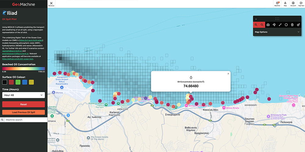
Image: Coastal Crete: Oil Spill Response
- Microbial Contamination and Public Health Risks: Insufficient real-time monitoring of microbial pollution in coastal waters affects public health, particularly in areas with high recreational and aquaculture activity. Policies require improved integration of microbial risk assessment with environmental data for timely decision-making.
Addressing these challenges is crucial for achieving the EU's water quality objectives and ensuring the health of marine ecosystems. Strengthening real-time monitoring, enhancing cross-border coordination, and integrating high-resolution forecasting tools are essential steps toward effective pollution control and water quality management.
Our recent analyses of pilot-policy relevance indicate that specific challenges, such as oil spill response, microbial contamination, and industrial discharges, require enhanced regulatory alignment and real-time monitoring improvements. The Ballast Water Monitoring & HAOPS and Jellyfish Swarm Forecast pilots highlight the necessity of integrating advanced forecasting tools with policy enforcement. Similarly, Aquaculture Risk Metrics and Water Quality - Plastic Pollution pilots underscore the importance of high-resolution data to bridge existing regulatory gaps in marine pollution management.
These efforts collectively aim to protect water resources, enhance environmental quality, and promote the sustainable use of aquatic ecosystems. However, improving cross-sector collaboration and integrating real-time monitoring data into policy implementation remain essential for achieving the EU’s long-term water quality objectives.
Iliad Digital Twin Solutions
Iliad offers innovative solutions to tackle these challenges through its specialized services:
Coastal Crete: Oil Spill Response
This pilot combines high-resolution local models with global-scale forecasting to predict oil spill trajectories and impacts in the Cretan Sea. It includes higher-resolution regional models for critical areas around Crete, enhancing preparedness and response strategies.
Oil Spill Predictive Models – Thracian Sea
This tool focuses on the Thracian Sea, this pilot integrates observational data with predictive modeling to enhance rapid response capabilities. It features geospatial visualization tools for displaying spill scenarios, aiding in effective decision-making during incidents.
Oil Spills Detection - Mediterranean Sea
The application is designed for monitoring and detecting oil spills to empower users worldwide to conduct regular assessments, contributing to the proactive prevention of future environmental damage. This is achieved using an anomaly-based approach, treating oil spills as environmental outliers, and utilizing baseline water parameter comparisons to detect and monitor sea oil spills effectively. The approach leverages satellite data, employing a combination of remote sensing techniques and advanced machine learning technologies.
OceanLab: A Digital Twin for Environmental Monitoring in the Trondheim Fjord
OceanLab, as part of the Norwegian Ocean Technology Centre, is an ocean observation and technology testing infrastructure in the Trondheim fjord, consisting of several strategically placed sensor platforms for oceanographic and weather data. A high-resolution operational ocean model for the fjord is under development, while it is covered by an 800m-resolution operational reanalysis from the Norwegian Meteorological Institute.
Current twin applications under development include:
- Environmental monitoring of essential ocean variables with feedback loop to the observatory
- Pollution monitoring incl. noise, methane, plastic, and backtracking of marine litter from real and what if scenarios
- Ocean particle monitoring and water quality assessments
- Biomass monitoring including autonomous vehicles guided by the DTO
The tool tracks marine plastic distribution and hotspots using satellite imagery and in-situ data. It supports compliance with directives like the MSFD by providing geospatial insights and quantification tools, facilitating targeted interventions to reduce plastic pollution.
Jellyfish Swarm Forecasting
Biodiversity & Seascape Ecology
The tool aims to revolutionize the assessment of coastal biodiversity and seascape dynamics using advanced data analysis techniques. Leveraging cutting-edge technologies, it seeks to unveil the intricate relationships between marine habitats and their inhabitants, ultimately contributing to more effective conservation and management strategies.
With a focus on understanding the complex interactions within coastal ecosystems, the tool integrates multidisciplinary data sources, including bathymetric surveys, habitat mapping, and biodiversity assessments. By employing innovative analytical approaches, it helps extracts meaningful insights into habitat suitability, species distribution patterns, and ecosystem health.
The DTO helps achieve:
- Comprehensive Data Integration: It aggregates diverse datasets, including bathymetric maps, species observations, and environmental variables, to provide a holistic view of coastal ecosystems.
- Advanced Analytics: Uses state-of-the-art analytical techniques, such as machine learning algorithms and spatial modeling, to analyze complex spatial and temporal patterns in biodiversity and seascape dynamics.
- Decision Support Tools: The DTO will develop decision support tools and habitat suitability models to aid in ecosystem management and conservation planning, empowering stakeholders with actionable insights.
- Collaborative Framework: Facilitates collaboration among researchers, conservationists, and policymakers to facilitate knowledge exchange and promote evidence-based decision-making for coastal management.
Invasive species and Harmful Aquatic Organisms and Pathogens (HAOPs)
This tool, together with shellfish farmers, interprets raw data to create information on suitability of sites using oxygen levels, salinity, surface temperature, nutrient concentrations, etc. Combined with the use of Spatial Multi-Criteria Evaluation (SMCE) by soliciting feedback from ML, eDNA data, and citizens, it provides forecasts and models on shellfish farming vulnerability.
Hydromast - water flow and wave measurement device
An in-situ measurement device for measuring water flow velocity and direction, as well as water level height and wave parameters. It is a low-cost and easy to use device, ideal for long-time and/or distributed monitoring of coastal processes, near-bed currents, harbour flows, river flows etc.
The Hydromast can be deployed either as a stand-alone device with internal logging and battery pack or as an online device using the serial connection with reconfigurable embedded software. Hydromast can be equipped with communication capabilities to allow near real-time data transfer and monitoring.
Underwater Cultural Heritage
A comprehensive GIS-based set of maps that brings to life the archaeological wonders lying beneath the sea and along the shores. Users gain unparalleled access to detailed site information, integrating the precise locations and elementary details of these historical marvels. Key features of the DTO are:
- GIS Mapping: By applying interactive GIS mapping we allow you to dive into the intricate maps of the Israeli coast, showcasing designated underwater and coastal archaeological sites. These aren't your ordinary maps but a more detailed, plotted representation delivered on convenient sheets for ease of examination and appreciation.
- Comprehensive Archaeological Catalog: Accompanying the maps is an informative Excel table, meticulously curated to include essential details of each archaeological site, providing a foundation for educational, research and planning purposes.
- Access to Exclusive Publications: Your journey doesn't end at the sites. We extend your exploration into the depths of knowledge with scientific and popular publications on selected underwater findings, allowing you to delve into the stories and historical research that bring these submerged relics to life.
- Easy Data Sharing and Accessibility: Whether you're a researcher, educator, or history enthusiast, we understand the value of easy access. That's why we're committed to sharing our data via user-friendly platforms like SharePoint or Google Drive. Access to some of these resources is granted upon request, ensuring security and exclusivity.
- Continual Updates with Authentic Content: Stay connected with the latest discoveries and explorations as our collection of scientific articles, popular publications, documentaries, and media publications is continually updated and shared through ILIAD and other reputable online portals.
- Citizen Science: Get trained, get informed and contribute to the state of knowledge by sending your own observations to the project team.